Whenua Māori
Visualisation Tool
Nau mai, haere mai!
This website is intended to help Māori land owners and managers find out more about the physical characteristics, constraints and potential of their whenua Māori.
You can view a guide to navigating this site here.
The Whenua Māori Visualisation tool combines the most up-to-date environmental and land resource data from Manaaki Whenua (Landcare Research) with the updated property and legal data from Māori Land Online (Ministry of Justice).
The land block information used in this tool was last updated in February 2017.
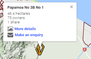
To use this site type the registered name or block ID of your Whenua Māori in the search box above. Alternatively using the map, zoom to the location of your land block and click on the land block's boundary.